
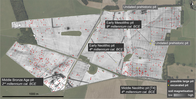
Researchers from the University of Birmingham and Ghent University (Belgium), have identified hundreds of possible large prehistoric pits and thousands of smaller ones at the heart of the ancient Stonehenge landscape. This discovery challenges our understanding of land use through time at this famous UNESCO World Heritage site, the most intensively investigated prehistoric monument in the world.
The Oldest Evidence of Land Use at Stonehenge
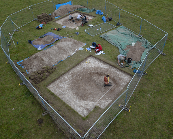
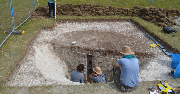
Writing in the academic “Journal of Archaeological Science”, the researchers report the discovery of a substantial pit, more than four metres wide and two metres deep excavated into chalk bedrock. Estimated to have been constructed over 10,000 years ago it stands out as the most ancient trace of land use yet discovered at Stonehenge. This prehistoric pit bears witness to hunter-gatherers roaming the landscape during the early Mesolithic, when Britain was re-inhabited after the last Ice Age. This is only one of many new sites and unexpected patterns of prehistoric activity detected at Stonehenge by the Ghent-Birmingham study team.
Unique Research
In a unique piece of research, extensive, electromagnetic induction surveying was combined with borehole analysis and twenty exploratory archaeological excavations. These revealed the extensive sub-surface pits.
Philippe De Smedt, Associate Professor at Ghent University and co-author of the scientific paper commented:
“Geophysical survey allows us to visualise what’s buried below the surface of entire landscapes. The maps we create offer a high-resolution view of subsurface soil variation that can be targeted with unprecedented precision. Using this as a guide to sample the landscape, taking archaeological ‘biopsies’ of subsurface deposits, we were able to add archaeological meaning to the complex variations discovered in the landscape.”
Four Hundred Large Pits
The project team identified over four hundred potential large pits (each over 2.5 metres in diameter), of which six were excavated in the course of the project, ranging in date from the Early Mesolithic (c.8000 BCE) to the Middle Bronze Age (c.1300 BCE).
While each of these sites adds to our knowledge of prehistoric activity in the Stonehenge landscape, the Mesolithic pit stands out as exceptional. The size and shape of the pit suggest it was probably dug as a hunting trap for large game such as aurochs, red deer and wild boar. Dating to 8200-7800 BCE, it is not only one of the earliest of the very few Mesolithic sites near Stonehenge (predating, for instance, the Blick Mead occupation site 1.5 kms away), it is also the largest known Early Mesolithic pit feature in north-western Europe.
Everything Dinosaur acknowledges the assistance of a media release from the University of Birmingham in the compilation of this article.
The scientific paper: “Novel Insights into Prehistoric Land Use at Stonehenge by Combining Electromagnetic and Invasive Methods with a Semi-Automated Interpretation Scheme” by De Smedt, Philippe, Paul Garwood, Henry Chapman, Koen Deforce, Johan De Grave, Daan Hanssens and Dimitri Vandenberghe published in the Journal of Archaeological Science.
Visit Everything Dinosaur’s website: Visit Everything Dinosaur’s Website.


Leave A Comment