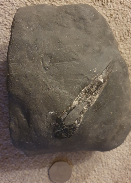
Recently, Everything Dinosaur was contacted by Lee who had collected a strange rock whilst visiting Yorkshire. Lee asked what the rock could be and sent in some photos. We contacted Lee and asked him to send in some more pictures, but this time including an object such as a coin that could provide a scale. In our email, we asked where this rock was found.
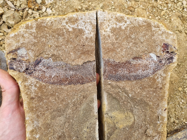
A fossil from Robin Hood’s Bay. Picture credit: Lee.
Robin Hood’s Bay Fossil
Lee commented that this rock was found at Robin Hood’s Bay on the north Yorkshire coast. This is a part of the world we know quite well and it is famous for its fossils. The Redcar Mudstone Formation dominates the geology of this part of the English coast and we suspect that the rock is mudstone and the unusual object is the remnants of a Jurassic shelly invertebrate.
An unusual fossil from Robin Hood’s Bay on the North Yorkshire coast. We suspect that this a mudstone from the Redcar Mudstone Formation, with the remnants of a highly eroded shelly fossil dating from the Lower Jurassic. Picture credit: Lee
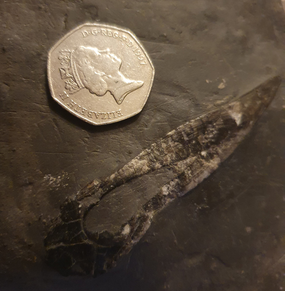
Lower Jurassic
The shales, mudstones and sandstones that outcrop at Robin Hood’s Bay date from the Lower Jurassic (Sinemurian to Pliensbachian fauna stages) and we suspect that this fossil is around 195 – 185 million years old.
The specimen is heavily eroded, and we think it is being viewed as a cross-section. Ammonites are relatively common on this stretch of coastline as are Gryphaea fossils (Devils toenails) and crinoids. It is very difficult to identify this item, just from the photographs, however, we think that as there seem to be striations (lines) visible in the fossil that this is a highly eroded bivalve.
A close-up view of the fossil from Robin Hood’s Bay. The coin provides a scale. Picture credit: Lee.
Any Suggestions
We know that many of our blog readers are enthusiastic fossil collectors. We would welcome any suggestions and help with the identification of this specimen.
For replicas of ammonites and belemnites take a look at this section of the Everything Dinosaur website: CollectA Prehistoric Life Models.
Sometimes dinosaurs can be spotted in the most unusual places. For example, an eagle-eyed Everything Dinosaur team member spotted a fuelled by dinosaurs sticker on a car parked next to our “dino van” at our warehouse the other day.
Fuelled by recycled dinosaurs. A decal spotted on a car which was parked next to Everything Dinosaur’s “dino van”. Not sure if the statement made is technically correct but we appreciated the sentiment. We note the Americanised spelling of “fueled”. Picture credit: Everything Dinosaur.
A Mistaken Assumption
The idea that petrol and other oil derived fuels are made up of the constituents of dead dinosaurs is a common assumption. Unfortunately, whilst it might please a petrol head to think that their super-charged, sports car is powered by long extinct animals like Triceratops and T. rex, this is not true. Fossil fuels such as petrol and natural gas are derived from the remains of (mostly) plant matter such as plankton (algae) laid down in a marine environment.
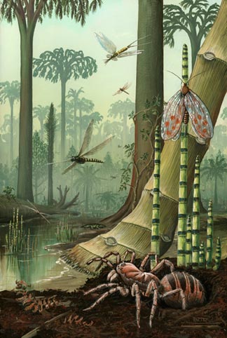
Most people understand that coal is derived from plant material, in the case of the UK, our plentiful and ubiquitous supplies of coal that fuelled the industrial revolution and industry until very recently largely consists of the remains of Carboniferous swamps and forests.
By the Carboniferous, the insects were already highly diversified. These swamps formed the extensive coal measures associated with the UK. Picture credit: Richard Bizley.
Fuelled by Dinosaurs
We are sorry car fans, for all you petrol heads out there, your vehicle is not powered by dinosaurs but by the ancient remains of some of the simplest, yet most important organisms on Earth – marine plankton.
Still, it’s a thought. Perhaps some clever car maker or another part of the oil or automotive industry will latch onto this misnomer and use it in their advertising. After all, not so long ago, a well-known brand of petrol advertised its fuel by stating put “a tiger in your tank”!
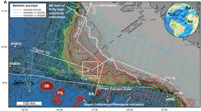
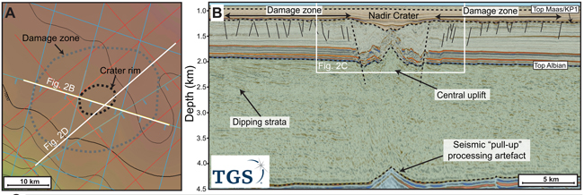
Researchers have found evidence of an extraterrestrial impact crater buried in sediments under the North Atlantic. The 5-mile-wide (8.5 km wide) crater, was caused by the impact of a bolide (crater forming body), at least 400 metres across. Detailed stratigraphic analysis indicates the crater was created at or very near the Cretaceous/Palaeogene boundary around 66 million years ago. This would make this collision potentially contemporaneous to the Chicxulub impact event. The scientists postulate that this impact was caused as part of a closely timed impact cluster or by the breakup of a common parent bolide.
Map showing the crater location on the Guinea Terrace with inset world map showing locations of Chicxulub (Ch) in the Yucatan Peninsula, Boltysh (Bo) crater in the Kirovohrad Oblast of Ukraine and the Nadir (Nd). These geological features are thought to be contemporaneous – all impacts occurring approximately 66 million years ago. Picture credit: Nicholson et al.
Buried Below the Seabed
The crater is buried 300 to 400 metres below the seabed some 250 miles (400 km) off the cost of the west African country of Guinea. Writing in the academic journal “Science Advances”, the researchers from Heriot-Watt University (Edinburgh), the University of Texas at Austin and the University of Arizona think that this impact occurred at around the same time as the Chicxulub impact that has been linked to the end Cretaceous extinction event that wiped out the non-avian dinosaurs.
To prove their theory, seabed core samples will have to be taken from the site. Lead author Dr Uisdean Nicholson, a geologist at Heriot-Watt University, has already applied for funding to drill into the seabed to confirm that it’s a bolide impact crater and establish the precise age.
The Cretaceous/Palaeogene Nadir Crater. (A) Seabed depth map of crater showing seismic line locations and the mapped extent of the crater rim and damage zone. (B) west to east seismic section (pre-stack depth migration – depth domain) across the crater, highlighting the crater morphology and damage zone, and the extent of subsurface deformation. Data courtesy of the Republic of Guinea, TGS and Western Geco. Picture credit: Nicholson et al.
Evidence of Impacts Extremely Rare
Evidence for extraterrestrial impact events is rare on planet Earth. Our dynamic geology and the effects of weathering have removed much of the physical evidence of even the largest bolide impact events in our planet’s long history.
However, for Dr Nicholson, seismic reflection data from the seabed immediately highlighted an unusual and unexpected geological anomaly.
Dr Nicholson explained:
“I’ve interpreted lots of seismic data in my time but had never seen anything like this. Instead of the flat sedimentary sequences I was expecting on the plateau, I found an 8.5 km depression under the seabed, with very unusual characteristics. It has particular features that point to an asteroid. It has a raised rim and a very prominent central uplift, which is consistent for large impact craters. It also has what looks like ejecta outside the crater, with very chaotic sedimentary deposits extending for tens of kilometres outside of the crater.”
This strange feature has been named the Nadir Crater, after a nearby seamount that lies to the west.
Other potential causes for this geological feature have already been discounted, Dr Nicholson added:
“The characteristics are just not consistent with other crater-forming processes like salt withdrawal or the collapse of a volcano.“
Impact Crater Potentially Linked to the Chicxulub Impact Event
The researchers suggest that the newly discovered Nadir crater could have formed by the break-up of a parent extraterrestrial body or from a series of Earth collisions by bolides.
Co-author Dr Sean Gulick, (University of Texas at Austin), stated:
“The Nadir Crater is an incredibly exciting discovery of a second impact close in time to the Cretaceous–Palaeogene extinction. While much smaller than the extinction causing Chicxulub impactor, its very existence requires us to investigate the possibility of an impact cluster in the latest Cretaceous.”
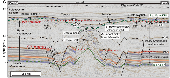
Detailed seismic stratigraphic and structural elements of the crater. The central peak is shown and the central uplift resulting from the impact. Picture credit: Nicholson et al.
Devastation of the Region
The researchers ran computer simulations in a bid to assess the consequences of an impact from a 400-metre-wide body crashing into water around 500 metres deep. The researchers suggest that the impact would have generated a tsunami over 1,000 metres high and an earthquake of 6.5 magnitude. Such forces would have had caused devastation.
Everything Dinosaur acknowledges the assistance of a media release from Heriot-Watt University and the open access paper published in Science Advances in the compilation of this article.
The scientific paper: “The Nadir Crater offshore West Africa: A candidate Cretaceous-Paleogene impact structure” by Uisdean Nicholson, Veronica J. Bray, Sean P. S. Gulick and Benedict Aduomahor published in Science Advances.
The thousands of articles on the Everything Dinosaur blog cover a huge variety of subjects. For example, prehistoric animal fossil finds, dinosaur discoveries, geology and updates on palaeontological research. Whilst reviewing our extensive database it was noted that in the earliest blog posts the extinction of the dinosaurs and the end of the Cretaceous and with it the termination of the Mesozoic Era, was stated as occurring approximately 65 million years ago. However, more recent posts refer to the end Cretaceous as occurring around a million years earlier.
When did this change occur?
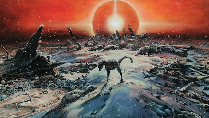
The K-Pg extinction event was exacerbated by the high levels of sulphur at the extraterrestrial impact site that led to prolonged global cooling, but when did this extinction event occur? Picture credit: James McKay
The K-Pg Extinction Event
Whilst there is been much debate as to the causes of the end-Cretaceous mass extinction event, accurately dating the extinction of the Dinosauria, the Pterosauria et al has always been controversial. If our blogsite is anything of a record, the first instance we have detected of a change in the date stated for the end of the Cretaceous occurs in a blog post from the 10th of December 2013. Our blog post for that day makes reference to the end of the Mesozoic occurring approximately 66 million years ago.
Geochronologists, most notably Professor Vincent Courtillot, have redefined the extensive volcanic activity that led to the formation of the Deccan Traps in India. It is now thought that the entire igneous emplacement took place in a relatively short geological interval (about one million years), and this volcanic activity occurred during the latest Maastrichtian and the early Danian. The Danian is the first stage of the Palaeocene Epoch that marks the beginning of Palaeogene Period of the Cenozoic Era. In addition, recent detailed analysis of the Chicxulub crater has indicated a formation date of 66,038,000 million years ago (plus or minus 11,000 years as a margin of error).
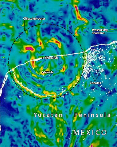
A geophysical map of the Chicxulub impact crater. Picture credit: NASA.
The International Commission on Stratigraphy (ICS)
It is a committee within the International Commission on Stratigraphy (ICS), that decides on the dates of geological boundaries, and during 2012/2013 revisions of the geological timeline took place including a change from the end of the Maastrichtian faunal stage from 65.5 mya (+/- 0.3 million years) to 66 mya.
Geological boundaries are subject to change. The development of consistent, extremely accurate numerical dating techniques and the continued acquisition of new numerical ages will continue to lead to refinements of the geological timescale.
As dating techniques become more sophisticated, it is to be expected that almost all the ages in the international chronostratigraphic chart will be subject to further revisions.
A farmer’s field in rural Gloucestershire (England), has provided palaeontologists with a remarkable glimpse into an Early Jurassic marine ecosystem.
Underneath a grassy bank, normally grazed by cattle at Court Farm, Kings Stanley near Stroud, lies an exceptional fossil site that contains the remains of fish, ammonites, squid, marine reptiles and other creatures, with many of the specimens preserved in three dimensions.
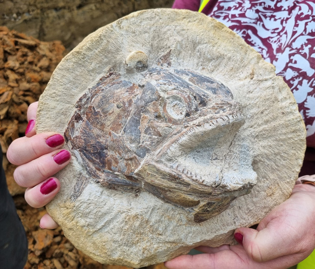
A three-dimensional fish skull (Pachycormus spp.) from a limestone concretion found at Court Farm. Note the small ammonite located in association with the skull. Picture credit: Dean Lomax.
A Toarcian Ecosystem
The clays and hard limestone nodules, many of which contain fossils, were deposited around 183 million years ago (Toarcian stage of the Early Jurassic).
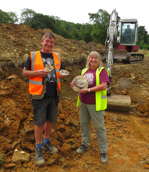
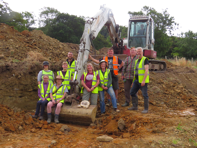
The site was discovered by Sally and Neville Hollingworth, avid fossil collectors who recently uncovered the remains of mammoths in the nearby Cotswold Water Park which was featured in the BBC One documentary “Attenborough and the Mammoth Graveyard” in 2021.
Neville and Sally Hollingworth at the dig site. Picture credit: Nigel Larkin.
Commenting on the significance of this location, enthusiastic fossil hunters Neville and Sally stated:
“These fossils come from the Early Jurassic, specifically a time called the Toarcian. The clay layers exposed at this site near Stroud have yielded a significant number of well-preserved marine vertebrate fossils that are comparable to the famous and exquisitely preserved similar fauna of the Strawberry Bank Lagerstätte from Ilminster, Somerset – a prehistoric site of exceptional fossil preservation. Excavations at Kings Stanley over the last week have revealed a rich source of fossil material, particularly from a rare layer of rock that has not been exposed since the late 19th century.”
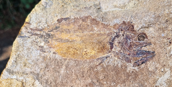
A stunning Early Jurassic Fossil fish from the dig site. Picture credit: Dean Lomax.
Limestone Concretions
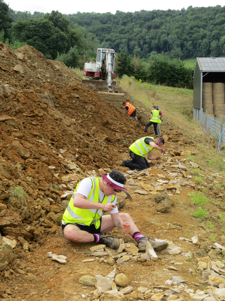
A team of eight scientists spent a total of four days working to clear an area of the bank approximately eighty metres in length. An excavator proved invaluable, but the field team still had to endure record breaking temperatures as they laboured to find and crack open three-dimensionally preserved limestone concretions, many of which contained fossils.
Field team members busy examining and splitting limestone concretions checking for fossils. Picture credit: Nigel Larkin.
Each specimen was carefully logged onto a database and approximately 200 kilograms of clay from around the concretions was also collected and carefully sieved using a state-of-the-art sediment processing machine to help locate microvertebrate fossils such as fish teeth and small bones.
The sediment processing machine used to help retrieve small fossils from the Lower Jurassic strata exposed at Court Farm (Gloucestershire). Note the novel use of two water troughs. Picture credit: Dr David Ward.
Fossils Donated to Local Museum
Many of the fossils found at the site will be donated to the palaeontology collection of a local museum (The Museum in the Park, Stratford Park, Stroud).
Team member and world-renowned, palaeontological conservator Nigel Larkin (Visiting Research Fellow at Reading University) commented:
“Give a person a fish and you feed them for a day. Give a palaeontologist a fossil fish and they will tell you the species, the age of the rock, the climate of the time when the fish was alive plus the water depth and salinity and plenty of other information. This site – already an interesting farm in a beautiful setting – is one big outdoor classroom and the lessons now include geology, palaeontology, evolution and climate change. They tell farmers to diversify but this goes one step beyond!”
Exceptional Fossil Fish Finds
Some of the best finds include fossil fish, so well-preserved that details of the scales, fins and even their eyeballs can be made out. One of the most impressive discoveries was a three-dimensionally preserved fish skull, a Pachycormus, (see first image), a genus of ray-finned fish known from the Toarcian of Europe.
The lack of any signs of scavenging of the corpses and the absence of encrusting animals or burrows in the sediment suggest that the fauna which was frozen in time under a farmer’s field was rapidly buried.
A limestone nodule spilt open reveals the fossilised remains of an Early Jurassic fish (slab and counter slab). Picture credit: Dean Lomax.
Splitting Concretions to Find Fossil Fish and Other Remains
The layered concretions around the organisms formed relatively early before the sediments were compacted, as the original sediment layering is preserved. These concretions prevented further compaction, compression and distortion from the overlying sediments during burial and thus preserved the fossils as three-dimensional time capsules.
Dr Dean Lomax, a palaeontologist and a Visiting Scientist at the University of Manchester, who recently led the excavation of the Rutland ichthyosaur that also dates to the Toarcian geological age, was part of the team he explained:
“The site is quite remarkable, with numerous beautifully preserved fossils of ancient animals that once lived in a Jurassic sea that covered this part of the UK during the Jurassic. Inland locations with fossils like this are rare in the UK. The fossils we have collected will surely form the basis of research projects for years to come.”
The dig team take a well-earned break, time for a group photograph. Picture credit: Nigel Larkin.
Landowner, Adam Knight, who has seen part of his farm temporarily converted into a real life “Jurassic Park” added:
“I’m delighted that after the initial work that Sally and Nev did over three years ago we now have a full-scale dig on the farm involving a range of fossil experts from The Natural History Museum, University of Manchester, University of Reading and The Open University. On Friday we were also joined by Emily Baldry on a day’s work experience before she goes to university to study palaeontology – it’s wonderful to see her enthusiasm for her chosen profession. It has been a real pleasure to host the dig and I’m excited to see the results of what has been found.”
Important Microvertebrates and Fossil Insects
Dr David Ward (research scientist at the Natural History Museum, London), outlined his contribution to the fieldwork explaining that his role was to collect evidence of all the small creatures that lived alongside the larger vertebrates and invertebrates in the ancient marine ecosystem.
The silty clay found in association with the limestone concretions was carefully washed and pushed through a fine sieve. Dr Ward’s wife Alison played a vital role in the collection process, and she added:
“My specialism is surface picking. This involves finding areas where fossils, particularly small bones and teeth, are naturally concentrated on the surface. Here, once I had collected them, I dug up the surrounding clay and fed it into David’s clay washing machine. The result is a fine concentrate of tiny fish bones and shells which we sort under a microscope.”
The Basis for a PhD
For Open University PhD student Emily Swaby, this fossil site has very special significance. Her PhD research is focused on how insects were affected by dramatic environmental changes that took place during the Toarcian. Fossil insects are extremely rare and although the Court Farm site represents marine deposition, insect fossils are known from such locations.
Emily commented:
“Further research at this site and surrounding Gloucestershire localities might help us to work out the abundance and diversity of insects during this time and help us to understand how this environmental change influenced insects.”
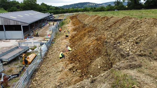
A view of the exposed strata at the Court Farm dig site. Picture credit: Steve Dey.
Everything Dinosaur acknowledges the assistance of a media release from the University of Manchester and additional information supplied by Dr Dean Lomax in the compilation of this article.
Hot weather can increase the risk of landslides and rockfalls, visitors to the seaside trying to avoid the extreme heat are advised to stay away from the cliffs.
For many parts of England, Monday and Tuesday (18th and 19th of July 2022), red extreme heat warnings have been issued. Such alerts have never been issued for the UK before. Temperatures could reach as high as 40 degrees Celsius (104 Fahrenheit), although this system of alerts was only introduced last year (2021). The risk of a landslide can increase in hot weather, visitors to the beach should take care to avoid areas where there are cliffs.
A significant rock fall at Stonebarrow Hill (Dorset).Extreme heat can cause cliffs to become unstable and collapse. Visitors to the seaside in search of relief from the hot weather are advised to avoid cliffs due to the increased risk of landslides and rock falls. Picture credit: Brandon Lennon.
Rock Fall and Landslide Risk
In very hot weather, the risk of landslides and rock falls increases. The heating up and then cooling of rocks can increase the instability of the rock face and this can lead to a collapse. The risk of landslides after heavy rain has been widely documented. Saturated, unstable ground can collapse, however, extreme daytime temperatures can also increase the risk of landslides and rock falls.
A spokesperson from Everything Dinosaur commented:
“We do advise visitors to places such as the “Jurassic Coast” and the north coast of Yorkshire to heed the warnings about unstable cliffs. The very hot weather is likely to lead to packed beaches and we urge everyone to stay away from dangerous areas.”
Landslides are common around some parts of the British coastline. Tragically, some incidents cause fatalities. In 2012, a woman was killed when she was caught in a massive landslide at Bridport (Dorset).
We urge seaside visitors to follow local advice and to avoid straying too close to the cliffs and the cliff edge when walking above the beach area.
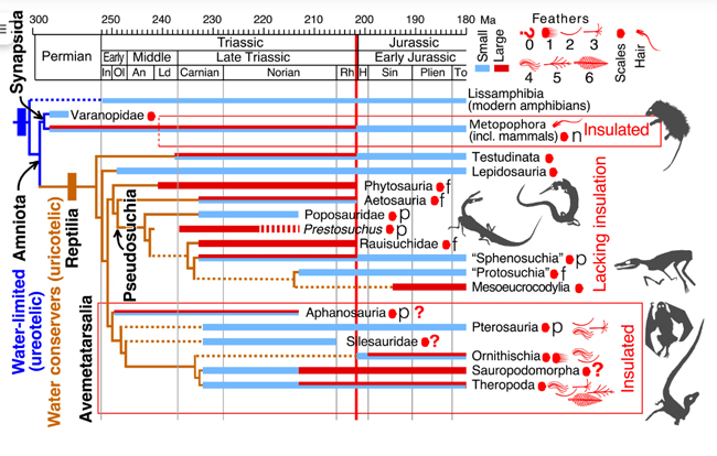
Scientists propose that cold snaps killed off the competitors of the dinosaurs and pterosaurs at the end of the Triassic opening the door for a dinosaur dominated Jurassic. The researchers propose that dinosaurs and pterosaurs with their integumentary coverings including primitive feathers, were insulated from the cold, whereas many other types of reptile co-existing with them just had scales. It was the body coverings that permitted the Dinosauria and the Pterosauria to thrive in cold conditions, whereas many of the other reptiles became extinct.
A beautiful feathered Compsognathus catches its lunch (artwork by Chuang Zhao). Fossil evidence suggests that many types of dinosaur were feathered, there is also growing evidence to suggest that pterosaurs too had insulating coats. A new theory proposes that these insulating coverings helped the Dinosauria and the Pterosauria to endure cold climates the onset of which led to a mass extinction event.
Ice-rafted Debris Discovered in Lakebed Deposits
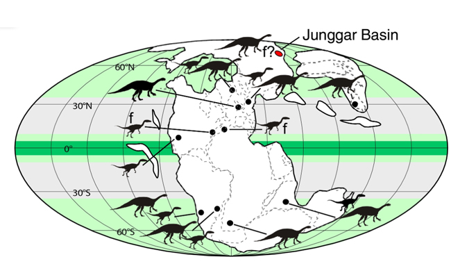
The research team which included Paul Olsen, lead author of the study (Lamont-Doherty Earth Observatory at Columbia University), examined sandstone and siltstone formations formed in lakebeds in China’s Junggar Basin. These deposits are Upper Triassic in age and at this time this part of China had a palaeolatitude of around 71 degrees north. It was well above the Arctic Circle. Footprints found by the researchers indicate the presence of dinosaurs. In addition, the lake sediments contained abundant small pebbles, and it was concluded that these pebbles represent ice-rafted debris deposits.
Map of Pangaea in the Late Triassic. The Junggar Basin is highlighted in red. Silhouettes show location and type of dinosaur known. Most dinosaurs were confined to higher latitudes and f signifies the presence of dinosaur tracks indicating their presence in the palaeoenvironment of the Junggar Basin. Picture credit: Olsen et al.
The Small Pebbles are Significant
The numerous small pebbles found amongst the fine siltstones and sandstones were probably deposited by melting blocks of ice. The research team, who included scientists from the Chinese Academy of Sciences, suggest that in the winter when the lake waters froze over, pebbles were picked up by the ice from the rocky lake shores. As the warm weather returned, the ice sheets would melt and chunks of ice would float away over the lake, gradually melting and as they did, they would drop the pebbles and other material.
Survival of the Fluffiest
The ice-rafted debris suggest freezing winters endured by dinosaurs. Around 201.6 million years ago, extensive volcanism which ejected millions of tonnes of debris into the Earth’s atmosphere lowered light levels and led to global climate change. Our planet endured a prolonged period of cold.
The cold decimated all medium-to large-sized non-dinosaurian, non-insulated continental reptiles. As they were adapted to cold climates, the Dinosauria and their cousins the Pterosauria were well placed to dominate terrestrial habitats as world temperatures plummeted.
The scientists concluded that many large reptiles that lacked thermal insulation that would have been provided by an integumentary covering died out during the End-Triassic extinction event. In contrast, pterosaurs and dinosaurs with their insulating coats were able to cope much better and survived this extinction event. The unoccupied niches in the ecosystem were soon filled as these archosaurs diversified in the Early Jurassic. Picture credit: Olsen et al.
Cold Climate
Lead author of the study Paul Olsen commented:
“They were [dinosaurs and pterosaurs] fundamentally cold-adapted animals. When it got cold everywhere, they were ready, and other animals were not.”
The scientific paper: “Arctic ice and the ecological rise of the dinosaurs” by Paul Olsen, Jingeng Sha, Yanan Fang, Clara Chang, Jessica H. Whiteside, Sean Kinney, Hans-Dieter Sues, Dennis Kent, Morgan Schaller and Vivi Vajda published in Science Advances.
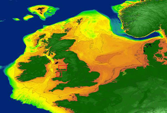
A study published in the journal Ocean and Coastal Management predicts that rising sea levels threaten 200,000 properties in England. Sea levels have changed before and a new research programme instigated by scientists at the University of Bradford is setting out to map Stone Age settlements that have been swallowed by the sea.
Approximate maximum extent of marine palaeolandscapes off the Irish and British coasts. Scientists plan to map Stone Age settlements that once existed on landmasses that are now submerged. Picture credit: University of Bradford.
Searching for Human Settlements
The archaeological study, the first of its kind in the world, is being led by Dr Simon Fitch, a geoarchaeologist at the University of Bradford. It will entail the use of unmanned underwater drones and advanced three-dimensional seismic sensors to map coastlines as they looked between 20,000 BCE and 10,000 BCE (BCE – Before the Common Era).
During the later stages of the Palaeolithic, sea levels were between 120 metres to 40 metres lower than they are today, the British Isles was still connected to the European mainland and much of the area we now refer to as the North Sea was land (Doggerland). This project aims to find evidence of human occupation in areas which are now underwater.
Dr Simon Fitch is a geoarchaeologist who has a long interest in the study of all aspects of submerged landscapes. Dr Fitch will lead the project to find evidence of Stone Age occupation in areas that are now under the sea.Picture credit: University of Bradford.
The “Life on the Edge” Project
The five-year project entitled “Life on the Edge” has received funding from several sources including the use of a vessel provided by the Flanders Marine Institute.
Commenting on the significance of this study, Dr Fitch stated:
“Our knowledge of the submerged coastal zones of the Late Palaeolithic is essentially non-existent and we have little to no knowledge on the settlement of these areas. This project will represent the first serious attempt to record these landscapes and understand the communities who lived on the edge of the continents.”
Ice Age Settlements
During the last glacial period, humans occupied the extensive plains that linked the British Isles to the European mainland. It is likely that there were many settlements and this project sets out to map the unexplored record of coastal occupation with the focus on three locations the coast of Scotland, Belgium and the continental shelf of Croatia.
Whilst looking backwards into human history, this research also has important implications for the future of humanity. The study will examine how people adapted to the challenges of sea levels and climate change – issues that threaten humanity today.
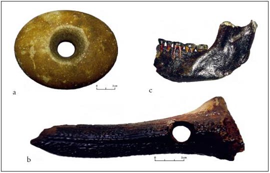
Brown Bank artefacts – A selection of prehistoric artefacts from Brown Bank (southern North Sea) collected by Dr Dick Mol polished stone axe mace head; b) perforated deer antler socketed adze axe head; c) human mandible, without scale from (Peeters 2011). Picture credit: University of Bradford.
Dr Fitch added:
“It is not hyperbole to say this is ground-breaking. This survey will provide significant advances in scientific understanding and the results will be of global importance, as it will vastly improve the methodologies available to investigate the vast inundated prehistoric landscapes that can be found around the world.”
Everything Dinosaur acknowledges the assistance of a press release from the University of Bradford in the compilation of this article.
It can be difficult to visualise the immensely long geological time scale and to demonstrate what lifeforms developed along the way, so, why not knit one and use prehistoric animal models to illustrate key moments in the history of life on Earth.
That’s exactly what Sue Mallender, Learning Programmes Science Officer, (Nottingham City Museums) and the Learning and Engagement team did – creating a colourful and striking depiction of the evolution of life on Earth.
Sue Mallender, Learning Programmes Science Officer, Nottingham City Museums (UK) has found a novel way of demonstrating deep time. The geological time scale has been knitted and prehistoric animal models placed on it at the appropriate point to demonstrate the evolution of life on Earth. Picture credit: Sue Mallender.
Visualising Geological Time
In order to study the history of life, scientists need to locate important evolutionary events such as the development of animals with exoskeletons and the evolution of vertebrates within the geological time scale. Planet Earth was formed around 4.57 billion years ago. Geologists have divided the history of our planet into time intervals of varying duration. This time scale was devised in the 19th century, (although amendments to it and revisions continue to be made). The boundaries between the time intervals mark notable events such as dramatic changes in the type of fossils found in strata.
Demonstrating deep geological time in knitted form. The geological time scale knitted by Helen Crowfoot. Picture credit: Sue Mallender.
It is difficult to understand geological time and a knitted time scale, with each boundary carefully produced in a contrasting-coloured wool provides a novel and very innovative way of demonstrating this fundamental aspect of geology.
This colourful visualisation of the age of our planet was created by dedicated knitter Helen Crowfoot.
The “Slow Burning Fuse” to Complex Life
The long interval of time from the origin of the Earth to the start of the Cambrian is referred to as the Cryptozoic Eon (meaning hidden life). This enormous time interval is also referred to as the Precambrian. Its length in comparison to the Phanerozoic Eon (visible life) – the time interval to the present day, is dramatically demonstrated in the knitted time scale by the burgundy-coloured strip.
Some palaeontologists have described the Cryptozoic Eon as the “slow burning fuse to complex life.”
A novel way of demonstrating the Cryptozoic Eon, informally known as the Precambrian – the immensely long period of time before complex life evolved on Earth. It is depicted in the time scale in burgundy. Picture credit: Sue Mallender.
Cambrian Creatures
A spokesperson from Everything Dinosaur commented that they had been contacted about this innovative project and ask to recommend prehistoric animal models that could be placed along the time scale to depict the sort of creatures that evolved during the main geological periods.
The Everything Dinosaur spokesperson explained:
“We started with the Cambrian, suggesting some figures that could represent some of the first, large complex animals and then worked forwards from there recommending various models that could be used to populate the knitted time scale.”
The Safari Ltd Cambrian Toob models placed on the knitted timeline. Picture credit: Sue Mallender.
The spokesperson added:
“What a super idea! This is a fantastic way to visualise geological time and we congratulate Sue and the Learning and Engagement team for such an innovative and creative way of demonstrating how life on our planet has changed over millions of years.”
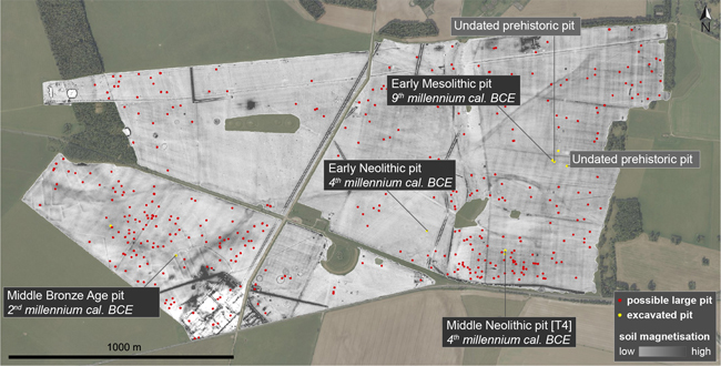
Researchers from the University of Birmingham and Ghent University (Belgium), have identified hundreds of possible large prehistoric pits and thousands of smaller ones at the heart of the ancient Stonehenge landscape. This discovery challenges our understanding of land use through time at this famous UNESCO World Heritage site, the most intensively investigated prehistoric monument in the world.
Hundreds of possible prehistoric pits detected in the landscape, indicating those that have been validated and excavated, plotted on a magnetic soil map from Stonehenge. Picture credit: De Smedt et al.
The Oldest Evidence of Land Use at Stonehenge
Writing in the academic “Journal of Archaeological Science”, the researchers report the discovery of a substantial pit, more than four metres wide and two metres deep excavated into chalk bedrock. Estimated to have been constructed over 10,000 years ago it stands out as the most ancient trace of land use yet discovered at Stonehenge. This prehistoric pit bears witness to hunter-gatherers roaming the landscape during the early Mesolithic, when Britain was re-inhabited after the last Ice Age. This is only one of many new sites and unexpected patterns of prehistoric activity detected at Stonehenge by the Ghent-Birmingham study team.
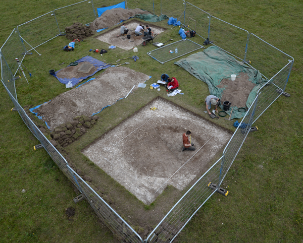
An overview of the excavation work. Picture credit: University of Ghent/University of Birmingham.
Unique Research
In a unique piece of research, extensive, electromagnetic induction surveying was combined with borehole analysis and twenty exploratory archaeological excavations. These revealed the extensive sub-surface pits.
Philippe De Smedt, Associate Professor at Ghent University and co-author of the scientific paper commented:
“Geophysical survey allows us to visualise what’s buried below the surface of entire landscapes. The maps we create offer a high-resolution view of subsurface soil variation that can be targeted with unprecedented precision. Using this as a guide to sample the landscape, taking archaeological ‘biopsies’ of subsurface deposits, we were able to add archaeological meaning to the complex variations discovered in the landscape.”
Four Hundred Large Pits
The project team identified over four hundred potential large pits (each over 2.5 metres in diameter), of which six were excavated in the course of the project, ranging in date from the Early Mesolithic (c.8000 BCE) to the Middle Bronze Age (c.1300 BCE).
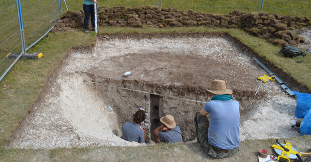
While each of these sites adds to our knowledge of prehistoric activity in the Stonehenge landscape, the Mesolithic pit stands out as exceptional. The size and shape of the pit suggest it was probably dug as a hunting trap for large game such as aurochs, red deer and wild boar. Dating to 8200-7800 BCE, it is not only one of the earliest of the very few Mesolithic sites near Stonehenge (predating, for instance, the Blick Mead occupation site 1.5 kms away), it is also the largest known Early Mesolithic pit feature in north-western Europe.
Collecting environmental samples in the Mesolithic pit. Picture credit: University of Ghent/University of Birmingham.
Everything Dinosaur acknowledges the assistance of a media release from the University of Birmingham in the compilation of this article.
The scientific paper: “Novel Insights into Prehistoric Land Use at Stonehenge by Combining Electromagnetic and Invasive Methods with a Semi-Automated Interpretation Scheme” by De Smedt, Philippe, Paul Garwood, Henry Chapman, Koen Deforce, Johan De Grave, Daan Hanssens and Dimitri Vandenberghe published in the Journal of Archaeological Science.